

One of the more spectacular drives in New Mexico is the Geronimo Trail National Scenic Byway, known to those of us in New Mexico as the Black Range Highway.
Starting in the town of Caballo just south of Truth or Consequences, the road snakes along, dips and climbs from 4,100 to 5,140 feet as it heads west to Silver City. From I-25 to Silver City is 75 miles, but there is much to see along the way, so plan on spending at least half a day on this trek.


As you take the exit from I-25, you are surrounded by high desert terrain, which includes wild grasses and a lot of creosote. This is cattle country and you will see them grazing along the highway, fortunately on the other side of a fence. As you head further along, there is risk of seeing deer, coyote, and other wild animals---especially if you are driving early in the morning or in the evening---so keep your eyes open. As you drive this road, you will also notice that most of the oncoming drivers will wave to you. This is what we do in New Mexico. Just wave back and smile.

After traveling for 13 miles, the terrain changes substantially. Instead of high desert shrub, you now start to see large rocks and more diverse vegetation, such as sotol, cacti, and yuccas. In two quick miles, the hills are much more rugged, and you will notice juniper and ocotillo; an odd mix anywhere else but New Mexico. In the distance are some very large peaks---the highest reaching 10,165 feet---which were snow-covered when I made this drive in early February.

Increasingly, the terrain is starting to look the way you think it should when you're in the Old West. That is, it is quite rocky, with varying shades of sandstone, ochre, and marbled browns. At this point, the road is starting to wind and you slowly descend into a valley.
The road you are on is in very good condition. It is easy to get distracted by all the scenery around you, but this is not a treacherous drive. On the day I drove it, the road was also very clean, with no litter to be found.

17 miles from I-25 you come to the town of Hillsboro. Most of the buildings you see around you were built between 1877 and 1940. After a 1877 discovery of gold and silver, Hillsboro became the Sierra County seat for 30 years.
There are two museums in Hillsboro. They are small and quaint, mostly exhibiting memorabilia of the families who used to live here. Most of the shops will be able to give you a copy of the Historic Hillsboro Walking Tour brochure, which goes into detail about the history of most of the buildings you see around you.

The road you are on has been designated a New Mexico Birding Trail by the State Wildlife Department. More than 40 sites of the most attractive birding locations throughout southwestern New Mexico are designated by this sign. You can also obtain a guide that includes maps, birding tips, site and descriptions by visiting: www.wildlife.state.nm.us

As mentioned above, the official name of this stretch of road is the Geronimo Trail National Scenic Byway, named for Geronimo, a famous Apache warrior.
Geronimo's early life was peaceful until the 1850s, when he went south to trade with the Mexicans. While there, a group massacred all the women and children from Geronimo's expedition, including his widowed mother, his wife, and three children. When the Apache's attacked the town in revenge, Geronimo fought so wildly that the Mexicans cried out to Saint Jerome for aid. The name became applied to Geronimo and it stuck.
Geronimo spent the rest of his life seeking revenge. Because of his love of the Black Range territory, it is fitting that the byway is named after him.

Heading west from Hillsboro, the next town you come upon will be Kingston.
To see the town, you need to veer right at the sign, as the buildings are not on the main road the way they are in Hillsboro. In the 1800s, Kingston had a population of 7000.
Now, it is mostly a ghost town.
By the time you reach Kingston, you are now in the Gila National Forest. The terrain is more mountainess, with juniper, pinon and other pines. Your surroundings do not fit with what you think of with New Mexico, unless you have also seen some of the other forested areas of the state, mainly north of Santa Fe or north of Silver City.
By this point, the road is climbing substantially and it winds a good deal. If you are driving by day, you don't need to be concerned, as the road is in good condition and there is excellent visibility in most places. You don't want to drive this road at night, or as I once did, in thick fog, where I couldn't see more than a few feet in front of my truck.

As you head further into the Gila National Forest, the road continues to wind and climb. Fortunately, there are a lot of pull-outs, should you need to let someone pass or take in the view behind you. When you look east, you see the valley you drove up through, with tall forested trees in the foreground, and flat, desert shrub in the distance.
Once you reach Emory Pass, you have come as high as you're going to go on this journey. There are some hiking trails to the right of the road, but those on the left have been closed due to residual damage from a fire that swept through here a few years ago.

The climb down from Emory Pass is not as steep as was your climb up. The first part still winds, however. Soon, you come to a grouping of boulders that leaves you feeling like you're on the set of the Flintstones. There are picnic areas and camping sites on both sides of the highway, but soon, you will be leaving the Gila National Forest.
As you look ahead, you see an expansive valley, with the hills peppered with junipers, other trees, and chamisa. Also known as Rabbit Bush, chamisa is known for its bright white or yellow flowers in the late summer.

Approximately 50 miles west of I-25 is the little town of San Lorenzo. This community is so small, that when I Googled it, another New Mexico town of the same name comes up, but this never does. The church is tucked away on a small street, and it was open, with prayer candles burning, on the day I visited.
San Lorenzo was named after Saint Lawrence. Saint Lawrence was one of seven deacons who were in charge of giving help to the poor and the needy. When a persecution broke out, Pope St. Sixtus was condemned to death. As he was led to execution, Lawrence followed him weeping, "Father, where are you going without your deacon?" he said. "I am not leaving you, my son," answered the Pope. "In three days you will follow me." Full of joy, Lawrence gave to the poor the rest of the money he had on hand and even sold expensive vessels to have more to give away.
In great anger, the Prefect condemned Lawrence to a slow, cruel death. The Saint was tied on top of an iron grill over a slow fire that roasted his flesh little by little, but Lawrence was burning with so much love of God that he almost did not feel the flames. In fact, he even joked. "Turn me over," he said to the judge. "I'm done on this side!" Just before he died, he said, "It's cooked enough now." Saint Lawrence's feast day is August 10th.
Just west of San Lorenzo is the turn-off for the Gila Cliff Dwellings. This piece does not go into that, but if you have the chance to go to the Dwellings, by all means do so. In terms of New Mexico sites, it's less populated than the others, so you'll practically have the park to yourself.

In the distance, you will see a rock formation that has come to be called the Kneeling Nun.
There are many legends about this, but the most common goes as follows:
In the early days of the Spanish Conquest of New
Mexico, a band of men under Coronado came through Santa Rita searching for gold. Shortly after, there came a band of monks and nuns, who built a monastery. Soldiers of Coronado's army
were brought to the monastery wounded and dying.
One of these soldiers was tenderly cared for by
a young nun, Sister Rita. Love came to these two, though Rita fought and prayed against it.
But alas, they were reported by a jealous man
and Sister Rita was condemned to die.
She prayed to be turned to stone and her wish was granted. A terrible earthquake shook the walls of the monastery and the kneeling nun form of Santa Rita remained.
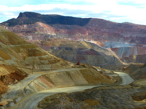
Below the Kneeling Nun is a massive mine, which you will soon see in its entirety on the left.
In 1799, during the Spanish colonial period, an Apache Indian showed Jose Manuel Carrasco an outcrop of copper. Carrasco, a retired lieutenant colonel in the Spanish Army, staked a claim and began to mine the copper in 1801.
In 1821, the territory passed from Spanish to Mexican ownership, and in 1853, the region became part of the United States with the Gadsden Purchase.
As you pass the mine, the expanse before you is incredible. I suspect that many of the mountains you see in the far distance are in Arizona and Mexico.

Just off the intersection of NM 152 and 356, is the Santa Rita Shrine.
It is literally on the southwest corner, up a small concrete ramp. As many times as I have driven this route, I never knew about this Shrine, which shows how easy it is to miss.
Santa Rita was born in Italy in 1381. She wanted to become a nun, but at the insistence of her parents, she married at the age of 12. Although her husband was mean and cruel, Rita remained a devoted wife until his murder 18 years later.
When her twin sons became intent on seeking revenge for their father's murder, Rita appealed to God to take her sons rather than have them commit murder. When her sons died, she applied for admission to the Augustinian Convent at Cascia, but was refused, as she was a widow. Through fasting, penance, and perhaps divine intervention, she was eventually admitted.
One day, while in prayer, she asked to suffer like Christ. The story has it that she was struck in the forehead by a thorn from Christ's crucifix, leaving a wound that never healed.
At this shrine is a statue of Saint Rita. In front of it is a memorial to Vietnam Veterans killed in action.

Within a few miles from the Santa Rita Shrine, you come to the intersection of NM 152 and SR 180. If you turn right at SR 180, it will take you to Silver City. Before you get there, however, on your right, is Fort Bayard.
Fort Bayard played an integral role in protecting settlers and miners in the Los Pinos and Silver City mining districts. Soldiers from the Fort battled many of the most famous Apache war leaders, including Victorio, Nana, and Geronimo.
The first all-African-American regular army units made up of enlisted personnel, referred to as Buffalo soldiers, were organized in 1866 in the close of the Civil War. Fort Bayard was home to hundreds of African American soldiers, who fought Apaches with distinction and who participated in the chase for Geronimo. His capture by Brig. Gen. Nelson A. Miles in 1886 effectively ended the Apache wars.
Write a comment
newmexicoexplorer (Saturday, 08 February 2014 05:38)
This is the first blog I wrote for this website. Your input, impressions, and feedback are welcome.
Jess Winfield (Thursday, 18 May 2017 23:02)
Hi, I'm interested in getting permission to use your photo of the Santa Rita shrine for a magazine article. No pay, but photo credit. Please contact me at jess@jesswinfield.com. Thx!
KSHWqSdC (Friday, 01 April 2022 16:58)
20
KSHWqSdC (Friday, 01 April 2022 17:01)
20
KSHWqSdC (Friday, 01 April 2022 17:01)
20
KSHWqSdC (Friday, 01 April 2022 17:02)
20
KSHWqSdC (Friday, 01 April 2022 17:12)
20
KSHWqSdC (Friday, 01 April 2022 17:13)
20
KSHWqSdC (Friday, 01 April 2022 17:18)
20
KSHWqSdC (Friday, 01 April 2022 17:26)
20